
How GPS Finds You

In this Interest


How GPS Finds You
Snapshot
GPS is a constellation of satellites that broadcast the time. Each message carries the satellite's position and the moment of transmission. Your receiver measures the travel time, turns it into a distance, and solves for the one position consistent with every distance it has.
The surprise is that the answer depends as much on your own clock as on the clocks in orbit.
By the end you will be able to say why four satellites are the minimum, why one microsecond is about 300 metres, and which failures belong to the signal and which to the map on your screen.
This brief runs about twelve minutes.

How GPS Finds You
Why Now
In June 2026 the GPS programme published the civil Integrity Support Message formats as change notice IRN-IS-200N-004, dated 16 June and signed on 14 August. Its stated purpose is to complete the integrity message format so that advanced receiver autonomous integrity monitoring can reach aviation users under RTCA/DO-401A and EUROCAE/ED-259B. The civil signal is gaining a way to tell a receiver that the data it is using cannot be trusted, without waiting for the satellite to be marked unhealthy.
The constellation is ageing in a countable way. As of 1 April 2025 it held 38 satellites with 31 set healthy, seven of them GPS III, while six Block IIR satellites averaged 23.2 years and the oldest was 27.7. Signal performance over the year to that date averaged 29.8 centimetres of user range error.
What has not changed is the geometry, the frequencies, or the fact that your receiver solves for its own clock error at the same time as its position.
How GPS Finds You
The Explainer
Four Satellites, Four Unknowns
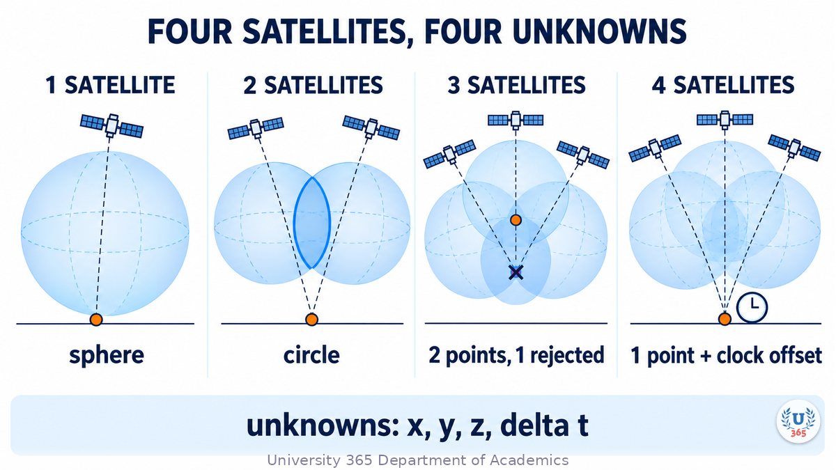
Distance from one satellite puts you somewhere on the surface of a sphere. Two spheres intersect in a circle. Three intersect in two points, and one of those is usually impossible because it sits above the satellites or below the ground. With perfect clocks, three would be enough.
Your receiver does not have a perfect clock. It has a quartz oscillator that may be off by a millisecond, and a millisecond is about 300 kilometres, because light covers 299.792 metres in a microsecond. Every range carries the same error, so the fourth satellite is not a fourth distance. It solves the fourth unknown, the receiver's own clock offset.
The Federal Aviation Administration states it plainly: an atomic clock synchronised to GPS would be needed for three ranges, and the fourth measurement removes that need. The unknowns are latitude, longitude, altitude and time.
A fifth satellite adds no unknown. It over-determines the solution, and the disagreement between five ranges is what lets a receiver check itself.
The Clock in Orbit
Each satellite carries atomic clocks, and the control segment keeps them honest: a master control station and an alternate, 11 command and control antennas and 16 monitoring sites, with fresh clock and orbit data uploaded daily.
The clocks need a correction unrelated to manufacture. NIST puts the two relativistic effects side by side. The satellite moves fast enough that special relativity should make its clock lose 7 microseconds a day against an earthbound clock, and it sits high enough in the gravity field that general relativity should make it gain 45. The net effect is 38 microseconds a day fast. Uncorrected, that is about 11 kilometres of range error a day.
The fix is built into the signal. The interface specification requires the clock rate to be offset by a fractional frequency of minus 4.4647 times ten to the minus ten, which on the 10.23 MHz fundamental is minus 4.5674 thousandths of a hertz, so the broadcast clock runs at 10.2299999954326 MHz. The receiver applies a second correction for the eccentricity of the orbit, because the satellite's height, and therefore its clock rate, vary slightly.
Position is a time measurement. One nanosecond is about 30 centimetres, so a receiver resolving a hundredth of a code chip is working at about 3 metres.
A Signal Weaker Than a Light Bulb
The minimum received power for the L1 civil signal is minus 158.5 dBW, about 1.4 times ten to the minus sixteen watts, or 188 decibels below a one watt light bulb. That is below the thermal noise floor of the receiver.
It is recovered by correlation. Each satellite broadcasts a pseudorandom code the receiver also holds. The civil code repeats every millisecond and is clocked at 1.023 MHz, so one chip is about 0.977 microseconds long and about 293 metres in space. The receiver slides a replica in time until the correlation peak appears and reads the offset. Offset is travel time; travel time times the speed of light is range.
The same signal carries a data message at 50 bits per second: the ephemeris, the clock correction coefficients, the almanac, the ionospheric coefficients and health flags. Correlation produces a measurement. The message says what it means.
The Error Budget
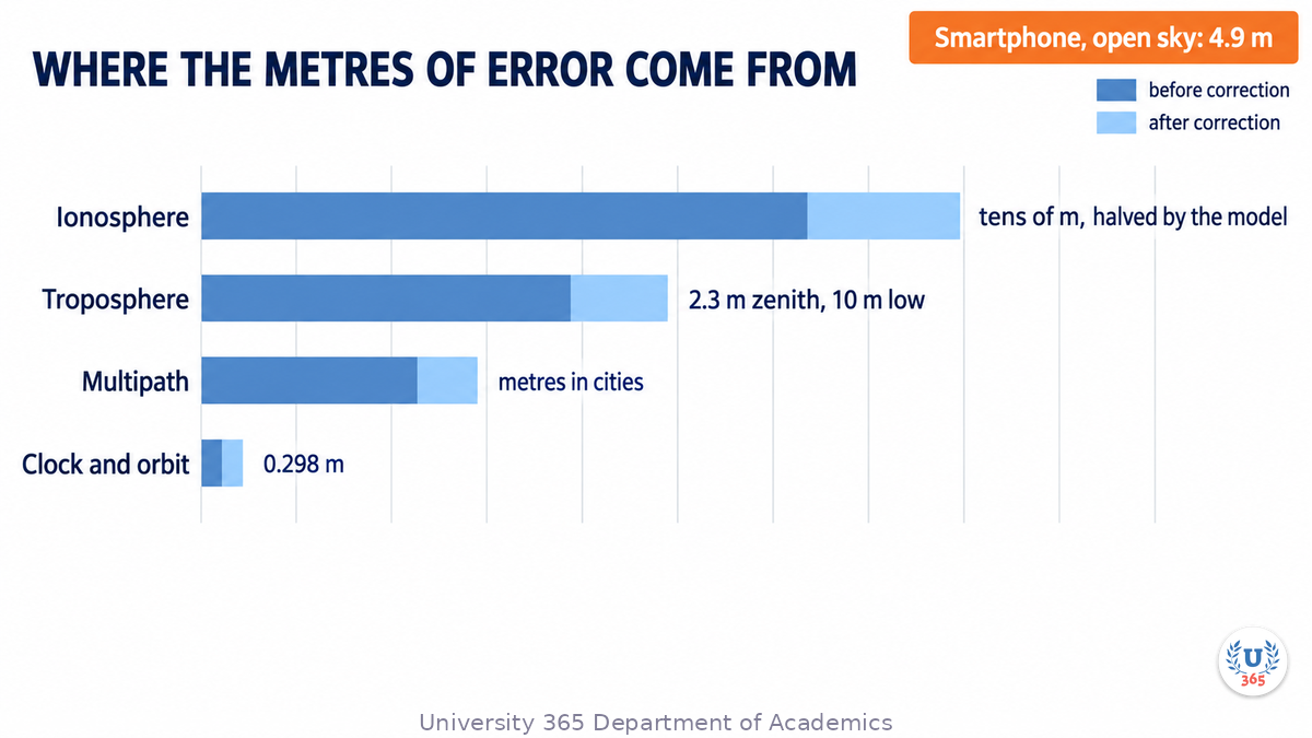
The ionosphere is the largest single-frequency term. It is a partly ionised layer that delays the signal in proportion to the free electrons along the path, and the delay depends on the sun, the season, the latitude and the angle at which the signal crosses the layer. ESA's reference text puts the delay at up to several tens of metres, while ESA's own introduction says several metres in the worst case. The difference is elevation and solar conditions.
The broadcast answer is the Klobuchar model, an eight parameter curve in the navigation message. It is an empirical model, not a measurement, and it is estimated to remove about 50 per cent of the ionospheric range error in root mean square terms worldwide. Dual frequency receivers do better, because the ionosphere is dispersive: two frequencies give two delays, and the difference yields the correction without a model.
The troposphere is smaller overhead and worse low down: 2.3 metres at zenith and about 10 metres at 10 degrees of elevation. It is not dispersive, so a second frequency does not help and only models or estimation do. Multipath comes next, from signals that reflect off buildings and arrive late, which is why a street degrades a fix that is fine in a field.
The last term is the satellite. The 29.8 centimetre average user range error is a signal in space figure, not your accuracy. Geometry amplifies it: four satellites clustered in one part of the sky turn the same range error into several metres on the ground. The published result for a phone under open sky is a 4.9 metre radius.
What Breaks It
Jamming is the blunt failure. A ground transmitter louder than the satellite in the same band swamps the receiver, and at minus 158.5 dBW the satellite is easy to drown. Jammers are illegal to market, sell or use in the United States, which has not stopped them being sold.
Spoofing is the sharper one. Psiaki and Humphreys define it as broadcasting false signals intended to be taken as authentic, so that a receiver reports a false position, a false time or both. A self-consistent spoofer receives the true signals, matches them, then drags them slowly enough for the tracking loops to follow. The authors describe a receiver and spoofer tested against a commercial receiver and estimate that a capability can be assembled for under 5,000 dollars from commercial signal generation hardware. Their list of exposed users includes cellular towers, power grid monitors and automated trading systems, which depend on GPS time rather than position.
The defences are layered. Receiver autonomous integrity monitoring catches a crude spoofer because the ranges disagree. Encrypted military signals resist the simple attack but not meaconing, which records and replays a real signal. Galileo broadcasts navigation message authentication, and the 2026 change notice extends civil integrity messages so that aviation receivers can compute an integrity bound.
Space weather sits outside all of it: a solar storm changes the ionosphere faster than the model is updated.
How GPS Finds You
The Feynman Summary
Four satellites broadcast the time, and each message states the moment it was sent. Your receiver notes when it arrived. The difference is travel time, and travel time times the speed of light is distance. One distance puts you on a sphere around one satellite. A second narrows that to a circle. A third leaves two points, and one of them is usually somewhere you cannot be.
That would be enough if your clock were perfect, and it is not. A quartz clock can be off by a thousandth of a second, which is 300 kilometres. So the receiver treats its own clock error as a fourth unknown and uses a fourth satellite to solve for it. It then knows the time as well as the position, which is why the same signal keeps bank transfers and power grids in step.
The satellites need correcting too. Their clocks run fast by 38 microseconds a day because they are high and moving quickly, and the hardware carries an offset that cancels most of it. What remains is atmosphere, reflections and geometry, which is why a phone under open sky lands within about five metres and a phone between buildings often does not.
How GPS Finds You
The Evidence
The primary document is the interface specification IS-GPS-200N, 248 pages, dated 22 August 2022. It defines the frequencies, the signal power, the codes, the navigation message, the relativistic frequency offset and the parameters of the ionospheric model. It is a requirements document, not a measurement: it says what the system must do, not what it achieved last month.
What it achieved comes from two places. The programme's public interface meeting deck of 12 May 2026 reports 38 satellites with 31 set healthy as of 1 April 2025 and an average user range error of 29.8 centimetres over the year to that date. GPS.gov states the standing commitment, a daily global average user range error of 2.0 metres or better at 95 per cent probability, and records that on 20 April 2021 the actual figure was 0.643 metres.
The atmospheric figures come from ESA's teaching reference, built from the literature rather than a measurement campaign. The relativity figures come from NIST, and the spoofing analysis is a peer-reviewed survey by two researchers who built the hardware they describe.
The limits are worth stating. User range error is a signal in space figure, not your accuracy, and the two differ by geometry and local conditions. The error budget figures are typical values drawn from models, not one controlled experiment, and the two ESA texts give different scales for the ionospheric term. The spoofing literature rests on laboratory and red team work, because no public census of real spoofing incidents exists. The constellation figures describe 1 April 2025, eighteen months before this brief was written.
How GPS Finds You
The Counter-Case
The strongest objection is that the textbook account is no longer how your phone works. A modern handset does not choose four satellites and solve four equations. It uses assisted GPS to fetch the almanac over the network, listens to every satellite in view, and fuses the result with Wi-Fi, cell tower and inertial measurements. On this reading, four satellites and four unknowns explain the principle and misdescribe the device, and the clock story is true but not the reason your blue dot behaves as it does.
A second objection concerns the threat. GPS has never been switched off since it was declared operational in 1995, Selective Availability ended in May 2000, and most complaints about a wrong blue dot are mapping errors rather than satellite errors, which GPS.gov says directly. Jamming is local and spoofing is hard, so the existential framing may be larger than the measured risk.
Both objections are partly right. What would settle the first is a published comparison of raw satellite positioning against the fused output on the same handset in the same places, and what would settle the second is a documented multi-day outage with user-level measurements. Neither exists as an open dataset, so the honest position is that the mechanism is settled and the user-level consequences are estimated.

How GPS Finds You
What It Means for You
This sits in Quality of Life. The blue dot is an estimate with a published error budget, and knowing it changes what you do when it disagrees with the world. A dot that jumps between buildings is multipath. A dot that is steady and wrong in an open field is more likely a map or an address database. A dot that is wrong and moving smoothly where jamming has been reported is a safety issue, not an inconvenience.
The second consequence is that you depend on GPS time even when you are not navigating. Card payments, mobile networks, power grids and financial settlement all use it, which is why a local jammer can cause damage that has nothing to do with directions. the Interests method page sets out how this class of brief is built and why the applied AI question is asked of every subject.
Check the map before the sky When a destination is in the wrong place but your position looks stable, the error is usually in the address data, and reporting it to the map provider is the fix.
Keep a copy that does not need a signal Download the offline map for any area where you will rely on navigation, because a receiver with no correction data and no network starts more slowly and is less accurate.
Treat timing as infrastructure If you run systems that stamp transactions or schedule jobs, know whether they take time from GPS or from the network, and what they do when the two disagree.
The Applied AI Connection
The detection problem in the last section is increasingly handed to classifiers rather than to fixed thresholds. Khan, Marata, Nurmi and Lohan (IEEE Access, 2026) trained four models, XGBoost, Random Forest, k-nearest neighbours and a convolutional network, on eight features taken after correlation inside the receiver: carrier to noise density, Doppler shift, delay lock loop output, correlator outputs, loop outputs and peak correlation. They trained and tested on two open recordings of real attacks, the Texas and Oakridge spoofing test batteries. On the same kind of attack it was trained on, every model passed 90 per cent average accuracy, falling to about 80 per cent on GPS L1 and 75 per cent on Galileo E1 when scored per satellite.
The number that changes how you read a vendor claim is the cross test. Trained on one recording and tested on the other, average accuracy dropped to 66 per cent or less. The technique and the task are real: a receiver that can flag a spoofed signal can fall back to another sensor instead of reporting a confident wrong position. What the paper shows is that generalisation, not detection, is the open problem. When a product claims 95 per cent detection, ask which recording it was tested on and whether the test attack was in the training set.
How GPS Finds You
The Five-Minute Version
GPS is a timing system that produces positions. Each satellite broadcasts the time and its own orbit. Your receiver measures four travel times and solves four equations for latitude, longitude, altitude and its own clock error. The fourth satellite exists because your clock is cheap, not because three distances are insufficient in principle.
The clock in orbit is the precision problem. Speed makes it lose 7 microseconds a day, weaker gravity makes it gain 45, and the net 38 is cancelled by an offset built into the 10.23 MHz fundamental, which is why the specification's number is 10.2299999954326 MHz. One nanosecond is 30 centimetres, so a receiver working at a hundredth of a 293 metre code chip is working at about 3 metres.
The errors that remain are atmospheric and local. The ionosphere can delay the signal by tens of metres at low elevation, and the broadcast Klobuchar model removes about half of it in RMS terms. The troposphere adds 2.3 metres at zenith and about 10 metres at 10 degrees of elevation, and no second frequency helps because the effect is not dispersive. Under open sky a phone lands within 4.9 metres; between buildings it can be much worse.
The failure modes are jamming, which is local and illegal in the United States, spoofing, which is a false signal meant to be believed, and space weather. The defence is layered: integrity monitoring inside the receiver, encrypted military signals, authentication and integrity messages on the civil side, and the habit of asking what a number was measured against before you trust it.

How GPS Finds You
Sources
All sources below were opened and read on 20 October 2026.
Space Segment GPS.gov, Space Segment (accessed 20 October 2026)
Control Segment GPS.gov, Control Segment (accessed 20 October 2026)
GPS Accuracy GPS.gov, GPS Accuracy (accessed 20 October 2026)
Trilateration GPS.gov, Trilateration (accessed 20 October 2026)
Interface specification US Space Force, IS-GPS-200N (22 August 2022)
Civil integrity change notice US Space Force, IRN-IS-200N-004 (16 June 2026)
Public ICWG presentation US Space Force, Public ICWG presentation (12 May 2026)
FAA, How It Works Federal Aviation Administration, GPS, How It Works (accessed 20 October 2026)
NIST, relativity National Institute of Standards and Technology, Putting Einstein to the Test (accessed 20 October 2026)
Ionospheric delay ESA Navipedia, Ionospheric Delay (2011)
Tropospheric delay ESA Navipedia, Tropospheric Delay (2011)
Klobuchar model ESA Navipedia, Klobuchar Ionospheric Model (2011)
Spoofing survey Psiaki and Humphreys, GNSS Spoofing and Detection, Proceedings of the IEEE (June 2016)
Machine learning detection Khan, Marata, Nurmi and Lohan, GNSS Spoofing Detection via Machine Learning, IEEE Access (13 May 2026)




Comments